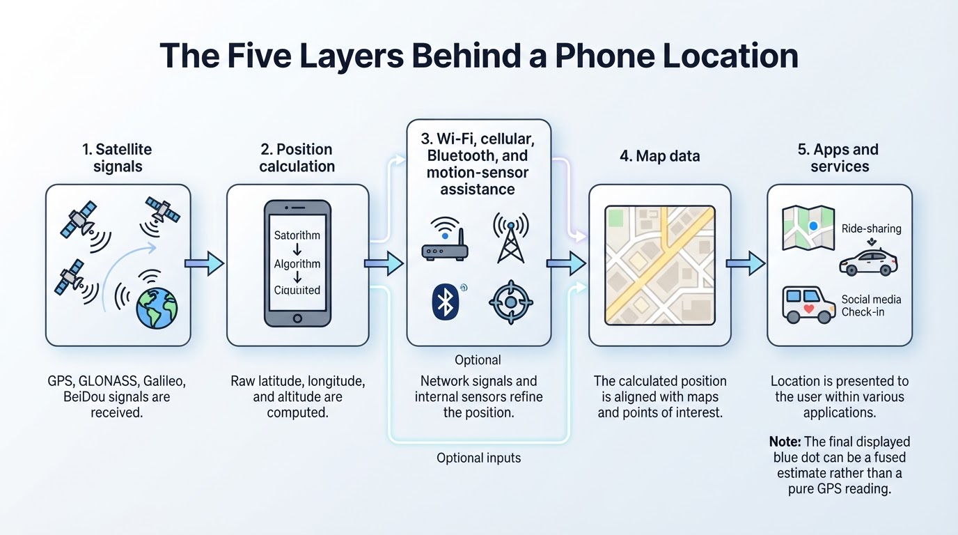
When your phone shows a blue dot, several systems may be contributing to that result. GPS is the United States-operated Global Positioning System, while GNSS is the broader category that also includes systems such as Galileo, GLONASS, and BeiDou. A receiver uses precisely timed satellite signals to estimate distances, solve for coordinates, and account for its own clock error. Your phone may then combine that estimate with Wi-Fi, cellular networks, Bluetooth, motion sensors, map data, and software. GPS positioning itself can work without sending data to satellites, but apps and services may separately transmit or store the resulting location. Understanding these layers makes it easier to see how GPS works, why a phone location can be inaccurate, and how to manage location privacy.
GPS, GNSS, Maps, and Location Services: What Is the Difference?
GPS, maps, navigation, and location tracking are related but different. GPS is one satellite-navigation system operated by the United States. GNSS is the broader term for satellite-navigation systems, including GPS and other constellations. A receiver calculates coordinates; map software gives those coordinates geographic meaning; navigation software calculates routes; and apps or online services may use, store, synchronize, or share the resulting location.
How GPS Satellites Help a Receiver Find Its Position
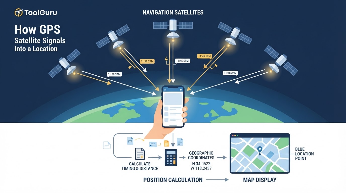
GPS satellites broadcast radio signals containing precise timing information and navigation data about their orbits and status. That information is maintained as part of the GPS system's control segment. A receiver compares when a signal was transmitted with when it arrived. Because radio waves travel at a known speed, the time difference can be converted into an estimated distance between the satellite and receiver.
The receiver combines measurements from multiple satellites and applies corrections and models for factors such as satellite-clock errors, orbital information, atmospheric delay, and signal quality. It then estimates latitude, longitude, altitude, and the receiver's clock offset. The Federal Aviation Administration provides an overview of this process in its GPS how-it-works documentation.
What Trilateration Means—and Why GPS Commonly Needs Four Satellites
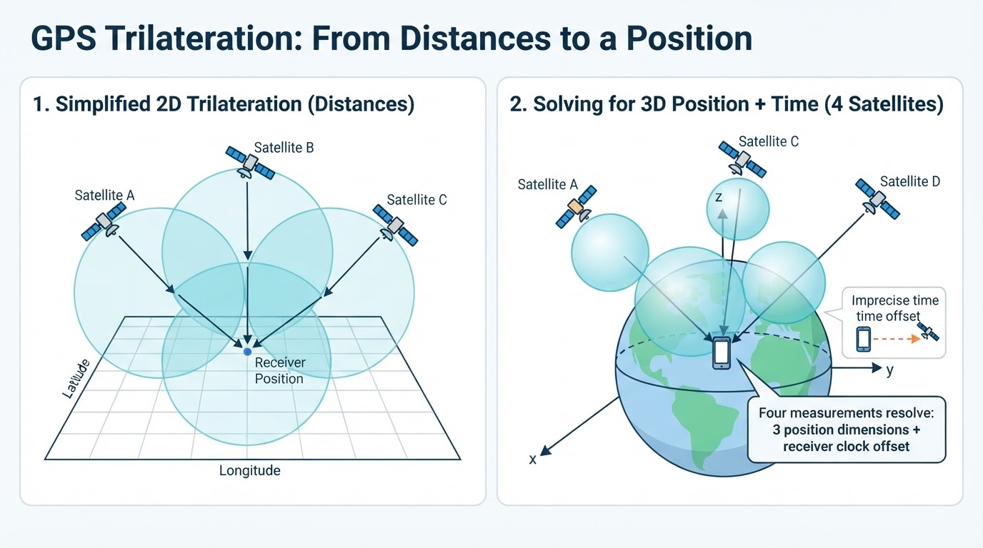
GPS primarily uses trilateration, not triangulation. Trilateration determines a position from distances to known points. Triangulation determines a position using angles. GPS receivers estimate distances from signal timing, so trilateration is the more accurate term. GPS.gov explains this distinction in its trilateration overview.
One measured range creates a possible sphere around a satellite. The receiver must be somewhere on that sphere. A second measurement narrows the possibilities, and additional measurements identify the position where the ranges best fit. In simplified two-dimensional diagrams, these appear as intersecting circles; in real three-dimensional positioning, they are spheres.
How Phones Find Your Location Beyond GPS
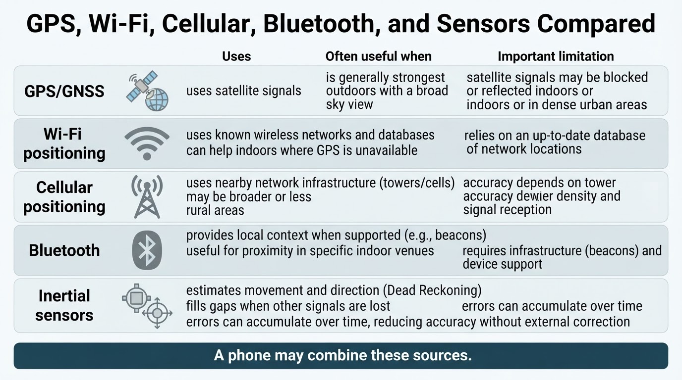
A smartphone may combine satellite positioning with other sources when satellite signals are weak, blocked, slow to acquire, or unavailable. Exact behavior varies by device, operating system, provider, region, permissions, and available network data. The operating system may present one fused location result without showing which source contributed most.
How Coordinates Become a Map Pin, Route, or Blue Dot
A receiver first produces coordinates. A mapping application then places those coordinates on geographic data. Navigation software adds destinations, route calculations, traffic information, and other service data. Differences between the calculated position and what appears on screen can therefore come from positioning, network estimates, map data, or display logic.
For example, map software may use map matching to associate a moving location with a nearby road or path. A misplaced pin can result from positioning error, Wi-Fi or cellular estimation, reflected signals, stale map data, inaccurate address information, map matching, or a mismatch between the coordinate and the displayed feature.
How Accurate Is GPS, and Why Does Accuracy Vary?
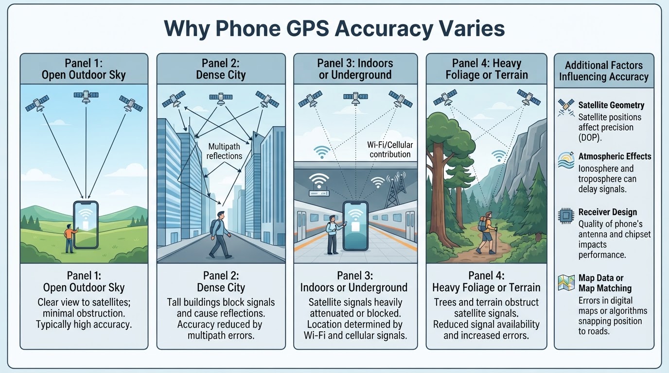
GPS accuracy is conditional and statistical, not a permanent guarantee or one universal number for every phone. A consumer device may perform well in an open outdoor area and poorly indoors, underground, beneath dense foliage, or among tall buildings. Altitude is often less reliable than horizontal position because vertical results are more sensitive to geometry and measurement errors.
Professional or survey-grade GNSS commonly involves specialized receivers, correction services, reference stations, or techniques such as RTK. A smartphone can be useful for everyday navigation and positioning, but ordinary settings do not automatically make it a survey instrument.
How to Improve an Inaccurate Phone GPS Location
Start by deciding what result you need. Approximate area identification, turn-by-turn navigation, outdoor tracking, offline travel, asset monitoring, and professional measurement have different requirements. A phone may be suitable for one task but not another.
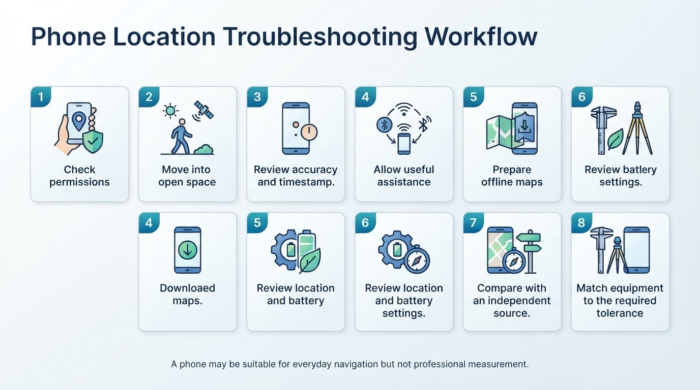
Use this general troubleshooting workflow. Menu names and available controls vary by operating system, device manufacturer, app, and software version:
- Check permissions. Confirm that the app has the location access it needs. Some devices and apps offer precise or approximate choices, but not all provide the same controls.
- Move into open space. If possible, test outdoors with a broad view of the sky. Keeping the device relatively still for a short period can make troubleshooting easier, but it is not a universal requirement for acquiring a fix.
- Check the reported information. Review any accuracy estimate, timestamp, or source status the app provides. Treat the accuracy value as an estimate, not a guaranteed boundary.
- Allow useful assistance when appropriate. Wi-Fi, cellular, and network assistance may improve acquisition or contribute to a fused estimate, but they do not guarantee stronger satellite reception.
- Prepare offline maps. Download map data before traveling where connectivity may be unreliable, and test the downloaded area and features before departure.
- Review device settings. Check location-service settings, app permissions, and battery restrictions. Battery optimization can affect some apps' background updates, but it does not uniformly reduce raw GNSS accuracy. Restarting location services or the device may help with an app or software problem.
- Compare independently. Test the phone outdoors and compare it with a genuinely independent receiver, known reference point, sensor, or map source when possible. Another consumer phone may share the same environmental or map-data errors.
- Match the equipment to the tolerance. For professional measurements, use equipment and correction workflows designed for the required accuracy rather than relying on consumer-phone settings.
GPS Privacy: Calculating a Location Is Not the Same as Tracking You
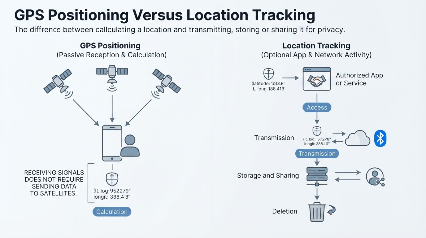
A GPS receiver ordinarily receives satellite signals and does not transmit a signal back to the satellites. That does not mean every use of GPS is private. A separate app, cellular network, Wi-Fi connection, Bluetooth-linked device, or online service may transmit the calculated location. Network-based estimates may also depend on external databases or services.
Privacy depends on permissions, background access, precise versus approximate location, account history, cloud synchronization, retention, and sharing policies. Repeated location records can reveal sensitive patterns such as home, work, routines, visits, and associations.
What GPS Is Used For—and When It Is Not Enough
Everyday GPS and GNSS uses include driving, walking, cycling, boating, outdoor recreation, fitness tracking, and waypoint recording. Professional uses include surveying, mapping, construction, precision agriculture, machine guidance, aviation, and maritime navigation. Satellite positioning can also provide time information for systems that require synchronization, although the specific equipment, design, and reliability requirements vary.
Fleet and asset tracking requires more than calculating a coordinate. A device also needs a communications path to transmit that position to a service. Emergency-location behavior is not determined by ordinary GPS settings alone and can vary by device, operating system, network, application, provider, and jurisdiction.
Safety-critical and professional applications may need redundancy, correction services, operational procedures, or independent positioning sources. A smartphone location estimate is useful, but it is not automatically suitable for every task.
Conclusion
GPS determines position by converting satellite signal timing into estimated ranges and solving for coordinates and receiver-clock offset. The technically correct term is trilateration, and four satellite measurements are commonly used for a three-dimensional solution because the receiver clock is not perfectly synchronized.
A phone's final location may combine GNSS with Wi-Fi, cellular networks, Bluetooth, sensors, maps, and software. That makes the blue dot a useful estimate, not an infallible raw GPS reading. Accuracy depends on the environment, satellite geometry, signal reflections, atmospheric effects, receiver design, and available correction services.
GPS positioning, map display, and location tracking are separate layers. Understanding those differences helps you troubleshoot an inaccurate location and review the permissions, history, synchronization, and sharing controls that affect privacy.